 Chinese
 English


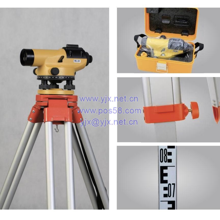
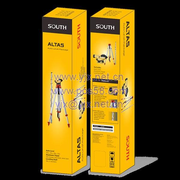
ALTAS LEVEL KIT-LEVEL+TRIPOD
ALTAS
-
● Auto Level
20X, 24X, 28X, 32X Optional
Accurate magnetic damping compensator
● Tripod
5/8 Thread, flat head, twist lock
Light weight but durable with carrying strap
Long-lasting painting
No shrinking or swelling in tough conditions
● Aluminum Staff
5m, 5 sections
With ABS buckle, levelling bubble for precise operation
Free extension with comfort and stable structure
Specification
| Auto Level | Magnification | 20X, 24X, 28X, 32X |
| Aperture | 34mm, 36mm, 36mm, 38mm | |
| Accuracy | 2.5mm, 2.0mm, 1.5mm, 1.0mm | |
| Image | Erect | |
| Field of View | 1°20’ | |
| Minimum Focusing | 0.6m | |
| Multiplication Const. | 100 | |
| Additive Constant | 0 | |
| Compensator Type | Magnetic Damping | |
| Compensator Range | ±15’ | |
| Compensator Accuracy | ±0.6” | |
| Sensitivity of Bubble | 8’/2mm | |
| Circle Graduation | 360 degrees or 400 gon | |
| Protection | IP54 | |
| Working Temperature | -20℃ ~ +50℃ | |
| Tripod | Extended Height | 1600mm |
| Closed Height | 970mm | |
| Locking Type | Twist Lock | |
| Head Type | Flat Head | |
| Head Size | 120mm /45mm | |
| Leg | Round Leg | |
| Aluminum Staff | Scale | Dual Sides, Large E and Millimeter Scale |
| Extended Height | 5000mm | |
| Sections | 5 Sections | |
| Deviation of each meter | ±0.5mm | |
| Overall Deviation | ±3mm | |
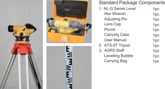
| Standard Package | Weight | 8.6 kgs |
| Dimension | 1265 x 240 x 210mm |
Note: all information above is subject to change without any prior notice.
SA130mini
H7 Brochure
UAV Fly2Map Series - SF1200 Brochure
AQUA M20 Pro Brochure
RobotSLAM Lite II Handheld Laser Scanner brochure
GNSS Automated Steering System SAG600 Brochure
SOUTH Intelligent 3D Excavator Guidance System EGS01
UAV Fly2Map Series - SkyCruiser VTOL Family Brochure
GNSS RTK Hybrid Supreme DotLas Plus Brochure
G8 Brochure
J1 Brochure
S7 Brochure
H9 Brochure
Insight V3 Brochure
N6 Series Egypt Tender
SOUTH: Mapping the Future with Spatiotemporal Intelligence Revolution
High Precision Auto Level DSZ1 Brochure
USV AQUA M20 Pro Brochure
GNSS RTK Hybrid Supreme DotLas Plus Brochure
ALPS2 Brochure
INNO4 Brochure
INNO5 Brochure
INNO6 Brochure
Insight V4 Brochure
NS10 Brochure
NS30 Brochure
SG130 Airborne LiDAR Data
Introduction to Total RTK ALPS1
Drone_eco_plus_operation_video_tutorial.mp4
Fly2Map Series - SkyCruiser VTOL Family Brochure V202411
High-Precision Aerial LiDAR System SA130 V202312
G7Q Brochure
SA130 Airborne LiDAR - Paving the Way for Railway Design Innovation
7tips of RobotSLAM Operations
SDE-18S Brochure
ALPS1 Brochure
SG130 Brochure
DL-2007A Brochure
FMOS Brochure
N2H Brochure
Insight V3 Brochure
H6 Brochure
AcuteLas Series SPL-1500/SPL-620/SPL-370/SPL-180 Brochure
SOUTH 2024
H10 Brochure
SOUTH S1
G4
AQUA M20
RobotSLAM Lite Handheld 3D Laser Scanner
INNO8
NS10
G4 Brochure
SurvStar CAD Draw-Draw CAD Anywhere, Anytime
Net S9 (1598)
Insight V2
NS30
RobotSLAM Handheld 3D Laser Scanner brochure V202412
POSEIDON SU30 (H16 version)
SOUTH S6
AcuteLas Series LiDAR SAL-1500 brochure V202207
Scan2Cloud series LiDAR-wiz brochure V202206
Remote Sensing Satellite Imagery brochure V202206
Portable LiDAR GoSLAM Series V202205
Fly2app series
VR Simulated Survey Training System
NL (es)
DL 202 (es)
INNO7
Galaxy G1 Plus
Galaxy G1
Galaxy G1 (IMU)
Galaxy G1 PLUS IMU (SOC)
New Galaxy G1
Galaxy G2
Galaxy G2 (1760)
Galaxy G3
Galaxy G5
Galaxy G6
Galaxy G6 (IMU)
Galaxy G6 (es)
Galaxy G7
G7
G9
NEW S86
H3 Plus
H3 Plus (No SIM version)
H5
H6
S660N
N80/ N80T
S750
T17N
T17N (No SIM version)
X1
X6
X11
N60
Compass 3
Net S9
Net S9 (336)
Net S9 (1598)
NET S10
NET S10 mini
CR3 G3
SDE-19
SDE-28S+
SDE-260D
SMOS
Slope Deformation Monitoring
SMOS cases study
SOUTH MR1
Tilt Sensor
POSEIDON SU30
SU12
SV30
Hysword SS500
T200
T400S Brochure
SOUTH S1
HX-CGX601A
HX-U202 35W Radio
HR1160B
HR842
SGO modified
ARF-AS1-3D-FS
Navi Station
A1
N1 Series
N3
N40 Series
N6 series Brochure
N8/N80 Series
N7 Series Brochure
NTS-332R10
NTS-345R6A
NT-023
NT-02D
ET Series
NL-C32
NL G Style
DL-202
DL-2003A
DL-2007
DSZ2
DSZ3
PD-5 Series
ALTAS
TERRA 12
UAV Fly2Map series brochure (V.202208)
UAV Automation & Parking System FlyAuto 01
A22
FLYme
One-Stop Automated Metro Tunnel Inspection System MS100 Brochure
MF2500
MF2500
LiDAR SZT-V100
LiDAR SZT-R250
Z-Lab LiDAR-eco Pro
R1000
SZT-R1000Ⅱ Series
Track Geometry Measuring Trolley System MEASLLEY IV brochure
PPK aeroPOS Software SkyLines
Solutions to Smart Applications& Location-based Services
CAD Mapping Software CASS
Cadaster Palm Surv-lution LandsMobile
One-stop Data Processing Package Solution
CAD MAPPING Software CASS10.0
Mini LiDAR System SZT-R250 (V.201901)


